Last November, after three years of relative silence, the Tennessee Department of Environment and Conservation finally presented to the public their plans for the first stage of “improvements” in what was to be the “minimally developed” Rocky Fork State Park. Part of the plan is a 24-foot-wide, two-lane, paved road that begins with a bridge over Rocky Fork Creek and extends ¾ mile to a campground and scenic overlook on Flint Mountain.
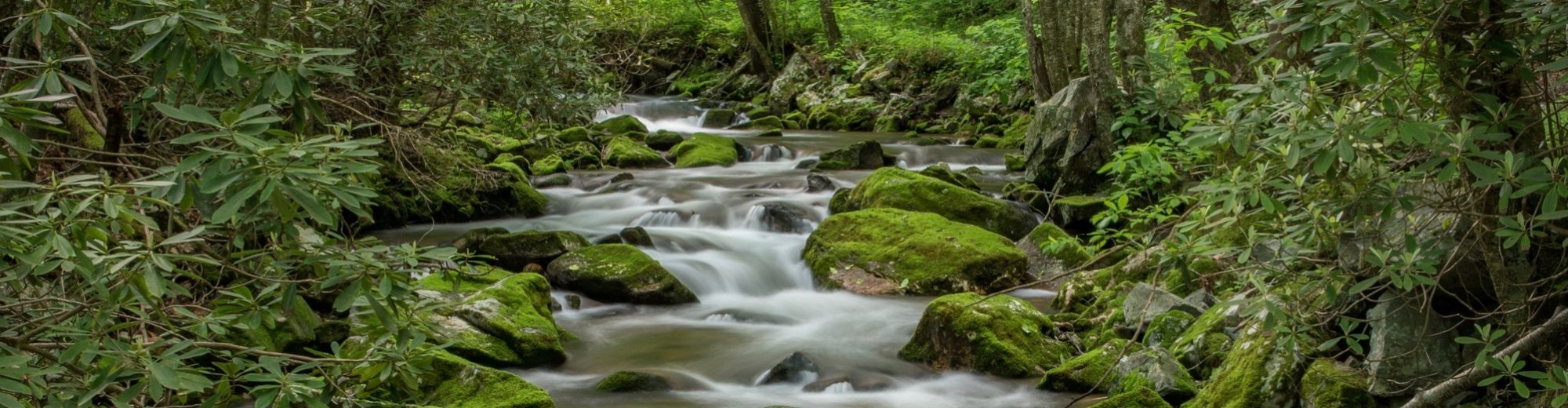
The photo below shows the approximate route of the road, now estimated by TDOT to be a $23 million dollar project, designed so as to be able to accommodate RVs and 2,000 to 4,000 vehicles per day. Due to the rugged and steep terrain, extensive use of retaining walls, massive road cuts, and metal reinforcement bolted into rock on slopes above would be required, leaving an ugly scar on Rocky Fork. Also, take note of the fact that a future stage of this development would be to widen the existing Rocky Fork Road to similar standards, changing the “prettiest mile of road in Tennessee” forever.

If this isn’t what you want to see in Rocky Fork I suggest a letter to the new Commissioner of TDEC, David Slayers (David.Salyers@tn.gov) and/or the interim Deputy Commissioner of State Parks, Anne Marshall (Anne.Marshall@tn.gov), asking that these plans, developed by the previous administration, be re-visited and public input sought to arrive at a better plan that the public supports, before permanently damaging the natural beauty we worked so hard to protect.

How was the route of the road produced? The first third of the route of the road looks correct, but I believe it actually goes to the left through that gap visible. Regardless of how accurate this depiction is, the road is a bad idea and a waste of tax-payer money, imo.
LikeLike
Thanks for paying attention Josh. I drew the road onto the photo and so it’s not perfect, but the old road grade is visible in the photo, especially the top 1/3, so I think its pretty close. Thru the gap to the left is my house!
LikeLike
I could’nt agree more Nancy, well said.
LikeLike
I moved to the head of Shelton Laurel in Madison County, NC because of the pristine area, natural trails, creeks and the mountains in 1977. Because we were close to TN we often shopped in Johnson City and Erwin, TN. To go to Asheville or Mars Hill we drove through Flag Pond, TN. We were very happy when I 26 opened in TN as our drive to NC towns was easier.
I was also very happy when Tennessee opened Rocky Fork State Park 15 minutes from me. Now, I had other lovely pristine trails to hike near me. When I heard the plans for development of a road through the park to take people to a high elevation I was shocked. To think RV’s would be traveling along the road to Erwin and Flag Pond would become a tourist destination upset me.
This whole area is truly pristine. People will come to the Rocky Fork, now named The Lamar Alexandria State Park, for the wild natural beauty it offers along the creek. Experienced hikers form everywhere will come to hike in and camp in the back country. Why ruin this small, very steep park with a road to an observation point when there are observation points driving along I-26. Why bring in RV’s and develop campgrounds ruining the natural area that is so lovely here? There are so many parks around us that offer these things. I don’t think TN needs a park on the state boundary just to show off another another high point with a scar of a road winding to that point.
Nancy Darrell
LikeLike
Nancy, I love what you wrote here and hope you will consider sending a version of it as a letter to the editor to Erwin, Greeneville, Asheville, wherever! With us, you are preaching to the choir, but we love to hear it!
LikeLike