When I was a kid growing up in the woods of East Texas, I joined Defenders of Wildlife and pored through the stories each month in their magazine—and that contributed to my growing love of nature. When they asked for volunteers to help capture the last Red Wolves, my dad and I went down and helped track the wolves and even got to see two of them loping along in the salt marsh.
The red wolf is still hanging on, but just barely, and at a recent event I met some folks with Defenders of Wildlife who are still at it, protecting our treasured wildlife. I was pleasantly surprised when one day I had a message waiting for me that Defenders had gotten word of the issue of development in Rocky Fork and the harm it would do to the wildlife and wanted to help me in my quest to protect the place and its natural wonders.
The mission statement of Tennessee state parks reads in part “to protect and preserve the unique natural, cultural and historic resources of Tennessee.” The State Parks Act of 1937, which created the parks, reads in part “that every park under the provisions of this act shall be preserved in its natural condition, so far as to be consistent with its human use and safety, and all improvements shall be of such character as not to harm its inherent recreational values.”
The current development plans for Rocky Fork State Park are not consistent with these provisions and should be revised, with an abundance of public input, until they are. The following fact sheet was recently prepared by three conservation organizations to help raise awareness of the threat Rocky Fork faces. Please feel free to show it to friends or contacts who want or need to know more about what is going on. Feel free to email me if you cannot readily access the document or want a PDF or another format.
Other voices besides our own have begun to be raised and heard on the issue. We appreciate anything and everything you do to help Rocky Fork. Sharing information, even with a few people, goes a long way toward the overall goal of making everyone who loves this place aware of the situation. Thank you!
Last November, after three years of relative silence, the Tennessee Department of Environment and Conservation finally presented to the public their plans for the first stage of “improvements” in what was to be the “minimally developed” Rocky Fork State Park. Part of the plan is a 24-foot-wide, two-lane, paved road that begins with a bridge over Rocky Fork Creek and extends ¾ mile to a campground and scenic overlook on Flint Mountain.
The photo below shows the approximate route of the road, now estimated by TDOT to be a $23 million dollar project, designed so as to be able to accommodate RVs and 2,000 to 4,000 vehicles per day. Due to the rugged and steep terrain, extensive use of retaining walls, massive road cuts, and metal reinforcement bolted into rock on slopes above would be required, leaving an ugly scar on Rocky Fork. Also, take note of the fact that a future stage of this development would be to widen the existing Rocky Fork Road to similar standards, changing the “prettiest mile of road in Tennessee” forever.
If this isn’t what you want to see in Rocky Fork I suggest a letter to the new Commissioner of TDEC, David Slayers (David.Salyers@tn.gov) and/or the interim Deputy Commissioner of State Parks, Anne Marshall (Anne.Marshall@tn.gov), asking that these plans, developed by the previous administration, be re-visited and public input sought to arrive at a better plan that the public supports, before permanently damaging the natural beauty we worked so hard to protect.
In November, for the first time in three years, Tennessee State Parks staff came to Unicoi County and held a public meeting to discuss management of Rocky Fork State Park. State Park officials presented plans for a visitor center and an access road to a campground and a scenic overlook; these plans were presented in final form, only awaiting permits before construction would begin.
The
general feelings we heard from folks at the meeting included serious concerns
about environmental damage as a result of the implementation of these plans,
and discontent about the plans not being influenced at all by public
input. Evidence available seems to
indicate that state parks staff are not very interested in the public’s opinion
or input, but rather are simply satisfying a requirement to hold a public
meeting and accept comments.
The
public was invited to submit comments for the following 30 days. Later, I
personally requested, twice, to review all comments submitted and did not
receive a response, but, after the recent removal of Deputy Commissioner Brock
Hill, asked again and did receive an incomplete collection of comments.
The
comments are public information and are excerpted here for you to see what others
think about the state’s plans, without identifying who provided each one. Roughly
60 comments vehemently oppose the plans presented with only two in favor. Contact
us if you would like the unabridged versions.
Notably
absent from the information provided by state parks were the comments submitted
by a number of conservation organizations, all of whom opposed moving forward
with the plans presented, including Southern Appalachian Highlands Conservancy,
Tennessee Citizens for Wilderness Planning, The Sierra Club, The Wilderness
Society, MountainTrue, and Wild South. A number of our friends’ comments were
also missing (we add some here) but it is clear that the public is
overwhelmingly opposed to the plans presented.
With this evidence that the public does not approve of the state’s plans, and the lack of public input to help shape those plans, we hope the new leaders will re-visit the issue before the heavy equipment moves in and changes Rocky Fork forever. We encourage you to send your letter to that effect to the new Commissioner of TDEC, David Salyers, Commissioner, Tennessee Department of Environment and Conservation and the acting Deputy Commissioner of State Parks, Anne Marshall (both at 312 Rosa L. Parks Avenue, Nashville, TN 37243). Letters to political leaders would be helpful as well including Governor Bill Lee, Senator Lamar Alexander, Congressman Phil Roe, and State Representative Rusty Crowe.
State parks in Tennessee are managed by a division of the
Tennessee Department of Environment and Conservation, which, under new Governor
Bill Lee, has a new commissioner: David Salyers. This change of leadership
presents an excellent opportunity to write a letter asking for a review of the
plans for Rocky Fork before any construction begins and permanent changes to
the landscape are made. The letter I sent appears below. Feel free to use it as
an example and write your own letter asking for proper care of this treasured
place. If you need a little more background, here are the issues in a nutshell:
The mission of Tennessee State Parks begins with preserving
and protecting the natural, cultural, and historic resources of the state. This
mission goes on to include recreational use, but the intent is clear that such
use shall not threaten those natural resources.
Tennessee state parks are highly developed with inns,
conference centers, restaurants, RV campgrounds, golf courses, swimming pools,
rental cabins, marinas, etc. Rocky Fork State Park was promoted from the start
as a “primitive, minimally developed” park, and because it is a small portion
of the much larger Rocky Fork tract—10,000 acres protected for public use in 2008
at a cost of $40 million—the state should be obligated to live up to the original
plan and not overdevelop the park to the detriment of the surrounding public
lands.
Plans presented for the first step in developing the park include a two-lane paved road up Flint Mountain with an auto bridge over Rocky Fork Creek, a campground on the mountain (which will not include RVs “at this time”) a large visitor center where the current parking lot is, and widening of Rocky Fork Road. The state does not appear to be following the primitive, minimally developed philosophy we heard about early on.
Within Rocky Fork lies a significant historic
site, less than a mile from the parking area, near the confluence of Rocky Fork
Creek and Flint Creek, where several old farm fields are now. In January of
1789, during the short-lived State of Franklin movement, John Sevier lead a
militia to attack a group of Native Americans camped there for the winter. The
camp was destroyed, 145 natives were killed and buried there, and the rest
escaped or were taken captive in what was one of many military engagements
between Sevier’s militia and natives in what we know as the Chickamauga Wars.
After moving to the area, I heard numerous
versions of this story, most of which included an Indian village being wiped
out by soldiers with a Gatling gun. The site was neither a village nor wiped
out using a Gatling gun, which was not invented until the early 1860s. I have
combed through history books and libraries attempting to learn the true story,
and with the help of historians Lamar Marshall and Chuck Hamilton, give you
here the best version I can.
Prior to the revolutionary war, an agreed-upon
line existed basically running along the crest of the mountains, visible to the
east from Rocky Fork. Settlers from the colonies to the east were not to cross
the mountains into Indian territory. In the aftermath of the war the state of
North Carolina was extended west all the way to the Mississippi River. These
new lands of the state were wild, sparsely inhabited, and the long-time home of
the Cherokee, Creek, and other Native American groups. The loyalty of these
native groups was divided since the French, English, and Spanish had been
present there, befriended the Indians through trade, and sought their help to
check western expansion of the colonies. White settlers from the east now spread
across the mountains into land only recently claimed by the new United States
of America and the infrastructure of government and military protection did not
yet exist.
The newly enlarged state of North Carolina, in an
effort to rid itself of debt to the federal government due to the war effort,
ceded the new lands back to the government to be used to form a new state, then
rescinded the cession, and later ceded the lands again, for good. Amidst the
confusion, the State of Franklin movement began, in which Sevier along with a
number of others declared their own state and formed their own militia to
protect themselves where North Carolina could not or would not. The State of
Franklin movement only lasted four years. The state of North Carolina never recognized
Franklin as legitimate and the movement dissolved; loyalty remained with North
Carolina. The lands to the west first became The Territory South of the Ohio,
and a few years later became the new state of Tennessee and Sevier its first
governor.
The native groups were divided themselves with
many realizing the futility in resisting the overwhelming surge of white
settlers and choosing to move on or assimilate, and others wishing to stand and
fight for their homelands despite the unlikeliness of success. Those continuing
to resist followed leaders like Dragging Canoe, Bloody Fellow, Old Tassell, Kitegisky,
Glass, Little Owl and John Watts, and early in the resistance camped on Chickamauga
Creek near current day Chattanooga, TN. These resistance warriors became known
as Chickamauga for the name of the creek and were not a separate tribe.
John Sevier was a notorious Indian fighter and
the military leader of the State of Franklin attempting to make the area safe
for settlers. Sevier fought many battles with the Indians and destroyed many
Indian towns prior to the Flint Creek engagement. As part of the effort to rid
the area of Indians, bounties were paid for Indian scalps, prisoners routinely
taken for later exchange, and Indian towns looted for anything of value Sevier
and his raiders could carry away.
Following a big victory for the Indians at
Lookout Mountain in 1788, a band led by John Watts split off from Dragging
Canoe’s band and attacked Gillespie’s Station on the Holston River where they
took 28 prisoners. The band then attacked White’s Fort and Houston’s Station
and then camped on Flint Creek in the area we now know as Rocky Fork.
During this time Sevier was attacking Indian towns in retaliation and destroyed many. Those Indians not continuing to resist with leaders like Dragging Canoe and John Watts moved out of the area to the west and south. In January of 1789, Watts and his band were camped on Flint Creek and scouts had reported this to Sevier along with a report that the group intended to attack Sevier who quickly organized his militia to march on the camp. Sevier divided his troops to surround the camp and lead a surprise attack, which led to “a complete victory” which he described in a letter reporting the incident to his fellow officials of the State of Franklin. The letter is transcribed below and appeared in several newspapers in Charleston, SC, and Augusta, GA, a short time afterward. This was one of only two official reports made by Sevier of his 35 battles with the Indians:
“It is with the utmost pleasure I inform your honors, that the arms of Franklin gained a complete victory over the combined forces of the Creeks and Cherokees, on the 10th inst. Since my last, I received information that the enemy were collecting in a considerable body near Flint Creek, within 25 miles of my headquarters, with an intention to attack me. To improve this favorable opportunity, I immediately marched my corps towards the spot and arrived, after enduring much hardship by the immense quantities of snow and piercing cold. On the morning of the 10th inst., we were within a mile of the enemy. We soon discovered the situation of their encampment by the smoke of their fires, which we found extended along the foot of the Appalachian Mountain. I called a council of war of all the officers, in which it was agreed to attack the enemy without loss of time; and in order to surround them, I ordered Gen. M’Carter, with the bloody rangers and the tomahawk-men, to take possession of the mountain, the only pass I knew that the Indians could retreat by, while I with the rest of the corps formed a line extending from the right to the left of their wings. The arrival of Gen. M’Carter on the mountain, and the signal for the attack was to be announced by the discharge of a grass-hopper, which was accordingly given and the attack begun. Our artillery soon roused the Indians from their huts; and, finding themselves pretty near surrounded on all sides, they only tried to save themselves by flight, from which they were prevented by our riflemen posted behind the trees. Their case being desperate, they made some resistance, and killed the people who were serving our artillery. Our ammunition being much damaged by the snow on the march, and the enemy’s in good order, I found it necessary to abandon that mode of attack, and trust the event to the sword and the tomahawk; accordingly gave orders to that purpose. Col. Loid, with 100 horsemen, charged the Indians with sword in hand, and the rest of the corps followed with their tomahawks. The battle soon became general, by Gen. M’Carter’s coming down the mountain to our assistance; death presented itself on all sides in shocking scenes, and in less than half an hour, the enemy ceased making resistance, and left us in possession of the bloody field. The loss of the enemy in this battle is very considerable; we have buried 145 of their dead, and by the blood we have traced for miles all over the woods it is supposed the greatest part of them retreated with wounds. Our loss is very inconsiderable, it consists of five dead, and 16 wounded; amongst the latter is the brave Gen. M’Carter, who, while taking off the scalp of an Indian, was tomahawked by another whom he afterward killed with his own hand. I am in hopes this brave and good man will survive. I have marched the army back to my former cantonment, at Buffalo Creek, where I must remain until I receive some supplies for the troops, which I hope will be sent soon. We suffer most for the want of whiskey.”
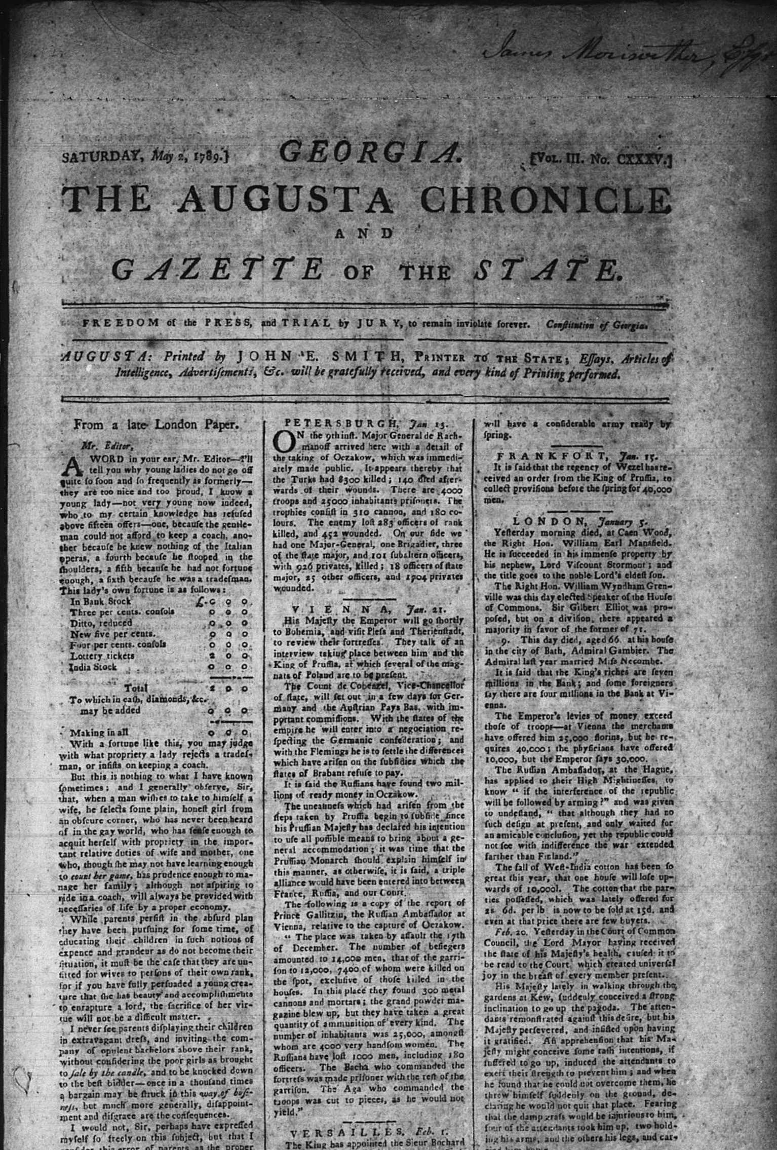
If you had been around in 1789, and in Augusta,
GA, in May, you could have picked up the May 2 edition of the Augusta Chronicle,
which contained Sevier’s letter announcing his triumph over the Indians. On the
same page can be found an article announcing salaries which had been set for officers
of the fledgling State of Franklin, with the top officials salary being 1,000
deer skins per year. Unlikely as it seems, the Library of Congress has a
microfilm record of that paper and a photo is included here so you can read the
news of the Flint Creek massacre just as folks in 1789 did.
John Brown in his 1938 Old Frontiers says “Flint Creek was the bloodiest of all fights in
the Cherokee wars.” The State of Franklin movement would end one month later
when Sevier pledged allegiance, once again, to North Carolina and thus this
event, more a massacre than a battle, became known as “The Last Battle of
Franklin.” In April, Sevier sent word to the Indians that he wished to make a
deal and a prisoner exchange took place in which at least two prisoners taken
at Flint Creek, a chief named Cotetoy and the daughter of Little Turkey, were
exchanged for at least two members of the Brown family, Joseph and his sister
Polly.
Although not the end of Indian hostilities, this
was a devastating blow to the Chickamauga band, which scattered west and south
and no longer posed a significant threat to settlers moving into the upper east
Tennessee area.
Sources of information about the Flint Creek
Massacre include:
The
Overmountain Men by Pat Alderman, 1970
Old Frontiers by John P. Brown, 1938
History of theLost State of Franklin by Samuel Cole Williams, 1889
If you had been around in 1789, and in Augusta, GA, in May, you could have picked up the May 2 edition of the Augusta Chronicle, which contained Sevier’s letter announcing his triumph over the Indians.The letter from John Sevier begins in the first column on this page under the heading George-town.
Thursday, January 10, 2019, the Tennessee Department of
Environment and Conservation, State Parks Division held a public meeting to
discuss a proposal to acquire the Morrill Electric property within sight of the
park entrance and apply for a grant from the EPA to clean up the contaminated
site and redevelop it for the park’s use. Due to the fact that notice of this
meeting was not released to the public until the day before the meeting, only
five citizens participated along with one reporter from the Erwin Record and
the park manager.
TDEC Grants Consultant Ryan Ray presented a proposal to
apply for an EPA grant of $500,000 to clean up the site, projected to actually
cost $618,000, the difference to be paid by TDEC. Although notice of this
meeting alluded to the site being redeveloped into an equestrian trailhead, Ray
confirmed that the grant is for cleaning up the site once TDEC acquires it and
does not pertain to the precise purpose for which the site is then redeveloped.
Ray presented to the group of seven present some options for
additional grants that would be pursued for funds to redevelop the site after
cleanup and acknowledged that future use of the site was a separate issue and
would be addressed at future public meetings and comment periods.
Although the small group seemed to all support the acquisition
and clean up of the site, several questioned the future use as an equestrian
trailhead and voiced opinions that the site would better serve the park as the
visitor center location.
Ray reconfirmed that future use of the site is not dictated
by the grant being applied for and that the various uses suggested other than
as an equestrian trailhead could be considered by TDEC and discussed with the
public at future meetings.
As for using the site as an equestrian trailhead, the park manager
confirmed that TDEC has been working on a plan for a new horse trail into the
park, which would start across the road from the site on property TDEC is
working to acquire but does not yet own. One might wonder, if the park acquired
land that would accommodate a new horse trail into the Flint Mountain area of
the park, the same area as the proposed campground, perhaps auto access to the
campground could be through that same property, thereby avoiding a great deal
of environmental damage from construction of the currently proposed road to the
campground area.
As for the reason for such short notice of this meeting, Ray
said TDEC did not want to address the public on the topic until they were at
least very close to a deal to acquire the property, and the grant sought has a
deadline for application of January 31 so a very small window was available and
the best he could do was a posting in the Erwin Record one day prior.
The acquisition and cleanup of this site seems to be a
worthwhile project and very beneficial to the area and Unicoi County, which is
currently stuck with an unusable contaminated site and could come away with a
nicely redeveloped facility.
However, this will run into the millions of dollars and the
future use of the site does create many questions that need to be addressed
with further public input.
With less than 24 hours notice, we have just received
the message below from the Friends of Rocky Fork State Park about a meeting to
be held tomorrow night, January 10, at the Flag Pond School, 917 Old Asheville
Hwy, Flag Pond, TN.
“Hello Friend’s Members,
Tennessee State Parks will be conducting a
public hearing tomorrow, Jan. 10th, at Flag Pond School at 6:00 p.m.
This meeting is regarding proposed application
for Brownfield clean-up funds from the United States Environmental Protection
Agency.
Tennessee State Parks will receive public comments
concerning the proposed action described below:
Facility Location: Morrill Electric Building
– 281 Jennie Moore Road, Flag Pond, TN 37657
Description: Tennessee State Parks proposes
to pursue funding through the United States Environmental Protection Agency’s
Brownfield Clean-up Grant to facilitate the clean-up of the Morrill Electric
Building site for redevelopment into an equestrian trailhead for Rocky Fork
State Park. The purpose of the hearing is to obtain views on parks needs,
review proposed activities and solicit public comments. The meeting is
open to the public and all citizens are encouraged to attend and make their
views known.
Hope you are able to attend.
Thank You,
Marie Rice”
There have been discussions about this site being
acquired and used for various purposes, and some feel it would make a better
home for the new state park’s visitor center. Even though this is very late
notice, we hope that some of you can attend the meeting.
A few years ago I had never used a computer, sent an email, or
been on the internet—and certainly never expected to have a blog.
For years I had lived off-grid in the woods, spending most
of my time backpacking all over the mountains—12,000 miles in all. Considering
all the places I had hiked, I set down roots in the best place I had found; the
mountains along the Tennessee–North Carolina border, just a little ways north
of the Smokies in Flag Pond, TN.
I chose this spot carefully due to the large amount of
protected land with only one missing piece: the 10,000-acre Rocky Fork tract.
It was soon to be acquired by the government, completing a huge swath of
protected land that would now be my backyard. I quickly purchased property
within walking distance of the tract and built a little homestead.
Four years ago, a lovely new wife joined me in the off-grid
cabin—bringing with her electricity, computers and the internet. That and the
realization that protecting a special place would require continuous diligence
ended my laid back, never-been-on-the-internet, just-grow-my-garden-and-hike-in-the-woods
lifestyle.
Rocky Fork has a great deal of interesting natural and cultural history to be explored, but finding information about it all can be a challenge. And so I have started a blog, the Rocky Fork Journal, to help others learn more about my chosen backyard—the wild, remote, unspoiled Rocky Fork watershed.
Rocky Fork Creek by Joye Ardyn Durham
Please check out the journal. It’s a work in progress and I welcome your feedback. Feel free to forward this to others who may be interested.