Under the new leadership of David Salyers at Tennessee Department of Environment and Conservation and Jim Bryson at the Bureau of Parks and Conservation, the plans for development of Rocky Fork State Park are being re-visited.
At two planning meetings last week—facilitated by Robert Reedy of Reedy and Sykes Architectural Consultants who have designed numerous facilities in Tennessee State Parks—input from many stakeholders was gathered to help guide new plans for the park. TDEC staff stated that the road up Flint Mountain is no longer being considered and announced other changes under consideration, such as moving the location of the visitor center to a site outside the park on the area’s main road.
The meetings were structured as charrettes with small focus groups discussing various topics including preservation of natural and cultural sites, types and locations of facilities, means of access to the park, recreational opportunities and development to support them, land management on park and surrounding forest service lands, and opportunities for economic development as a result of the park. These “roundtable” groups were facilitated by staff from TDEC, US Forest Service, Northeast Tennessee Regional Economic Partnership, and area park managers and rangers.
After the sessions, facilitators reported to attendees the predominant consensus of input for each group. These reports revealed the overall desire to preserve the park’s wild and pristine nature by limiting development and locating facilities outside the park. The input showed a preference for low-impact hiking, nature study, historic site interpretation, and overall protection and preservation of the ecology of Rocky Fork. There was widespread consensus that roads, buildings, and developed campgrounds are not appropriate in the park.
Images by Joye Ardyn Durham
These meetings mark the return of a Planning Office for State Parks, which has been absent in recent years, now brought back under the leadership of Anne Marshall, Senior Advisor to Jim Bryson. Rocky Fork stands to benefit as the first subject of an improved planning process now in the works.
Next, Reedy and Sykes will compile the input gathered last week into a report to present to TDEC in about one month. Then additional input will be sought if needed, and by April or May TDEC hopes to have a draft plan available for release to the public. When that happens there may be public meetings or there may simply be a public comment period, so be alert for your chance to provide your own input. TDEC hopes to have a final plan in place by July.
We are so fortunate to live in an area with a great deal of public land where we can get out and experience the natural world—more often than not by hiking the many trails. For many hikers there comes a time when they realize the government does not build and maintain those trails, volunteers do, and the hiker becomes a trail worker. Trail workers find the enjoyment of working in the woods with their friends equal to, if not greater than, that of a simple hike, and the satisfaction of giving something back can be downright addictive.
The 10,000-acre Rocky Fork Tract is crisscrossed by numerous old roads and trails long used by hikers, and a few years after the tract was acquired for public use and a portion became Rocky Fork State Park, volunteers began working on the existing trails there. A volunteer trail crew evolved that worked with park staff to remove blowdowns, cut back vegetation, and build bridges at stream crossings.
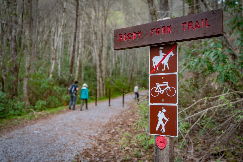
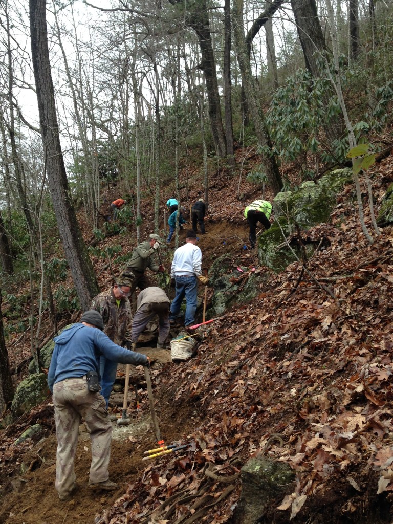
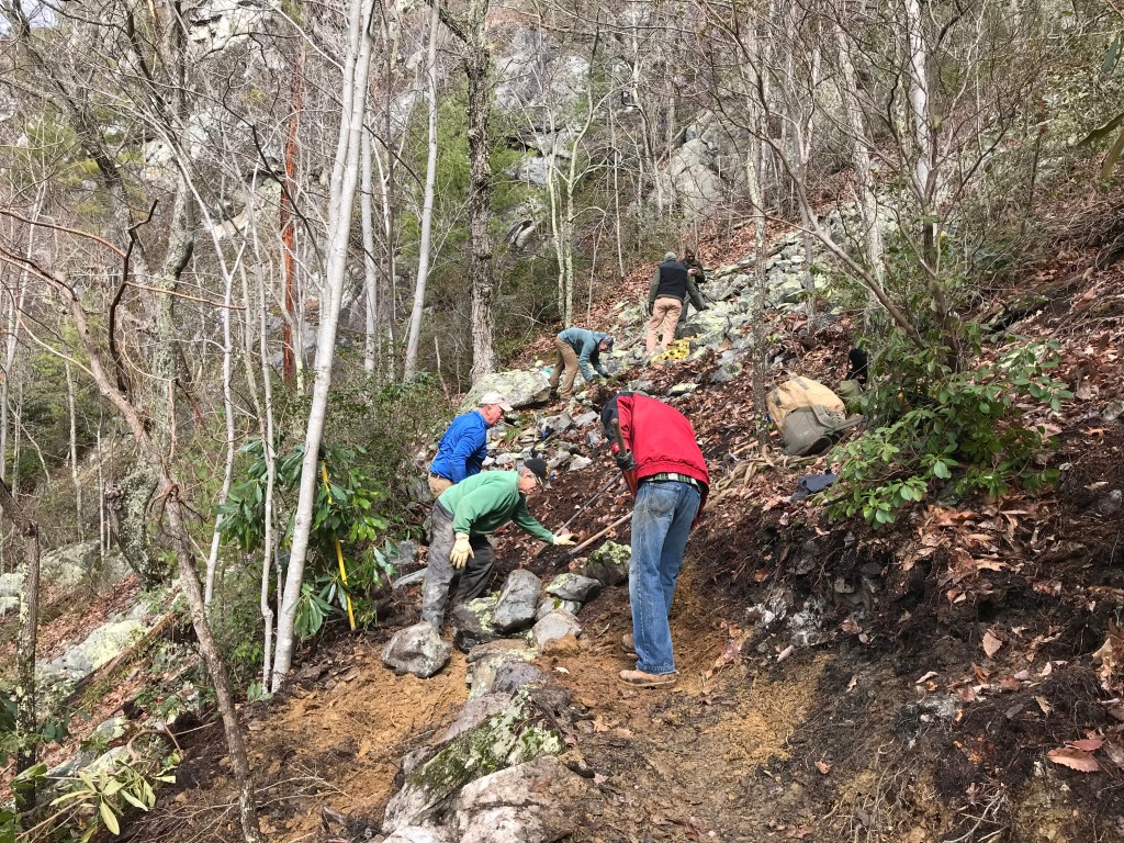
One of the more popular existing trails in the park, The Whitehouse Cliffs Trail posed some very serious problems, running right up a small creek, crossing property lines, and eventually going very steeply up a rocky slope to a spectacular 360-degree view. Being the closest trail to the park entrance and offering the best view in the park, a new trail was needed. There was talk of obtaining grant money for a new trail, using a trail dozer that could do most of the work, and hiring trail crews to build the new trail in what was expected to become about a three-year project. With none of that assistance in sight, the staff and volunteer trail crew began, on National Public Lands Day, September 26, 2018, to build the new trail the old-fashioned way, with hand labor.
The call went out for volunteers and they showed up, enjoyed the work, and quickly took the new trail out of sight of the parking lot and up the mountain. Then, in December, the government shutdown began and trail volunteers were banished from federal lands. People passionate about trails didn’t want to stop working on them just because the federal government was not working, and the Carolina Mountain Club asked, “Hey, that’s state-owned land, right? Can we come help?” Absolutely! Much progress was made during the 35-day shutdown and all of a sudden the new trail was halfway up the mountain.
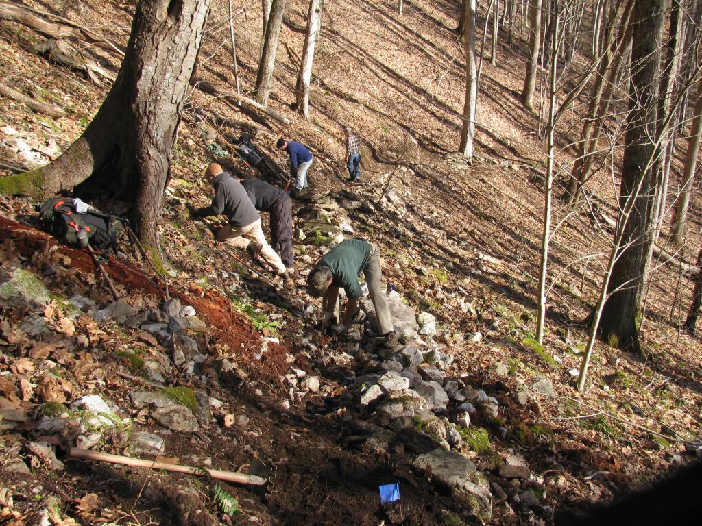
By the end of January, the shutdown had ended, Carolina Mountain Club had gone back to national forest lands, and the trail dozer had shown up, but was ineffective on the sleep slopes and rough terrain. The Rocky Fork Crew continued the work and reached the most challenging area to be tackled, a boulder field below the cliffs. The crew spent many days working in this boulder field moving tons of rock to create a small “bench” through the rock field to walk on. The view from this spot—of the cliffs themselves and the distant mountains and ridges—was spectacular and the crew repeatedly commented about what a great place they had to work. Once past the hardest part, it felt like they had success in hand, even though there was still a great deal of work to do.
Volunteers kept coming, even though it was now quite a walk up the new trail to the work site, including folks from Carolina Mountain Club, Tennessee Eastman Hiking and Canoeing Club, and Friends of Rocky Fork State Park. One-day work trips brought a group from Nuclear Fuel Services in Erwin, students from ETSU, Carolina Climbers Coalition members and some big strong teenagers from Holston Home for Children. The closer to the top the trail got the less soil there was to work with and it became mostly rock work, which is very slow and difficult, so even though the summit could be seen close by above, progress to reach it was slow. The rocky top of the mountain provides a nice, sunny location with numerous hiding spots for timber rattlesnakes, which were seen sunning themselves as they prepared to den up for the winter. The crew felt privileged to see these beautiful creatures and, combined with the forest and stunning views, the reason for public lands and trails was abundantly clear.
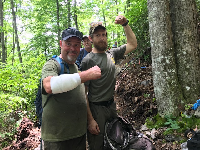
So now, as we approach the new year, a gift for everyone is completed: A beautiful new trail to a spectacular 360-degree view of the Southern Appalachian Mountains at their finest—cost to the tax-payers essentially zero. On 58 work days, 99 volunteers and 4 park staffers contributed 2,496 hours of work, 2,208 by volunteers, to build just over one and a quarter mile of trail. The trail includes 175 stone steps, hundreds of feet of rock cribbing to support the trail on steep slopes, and 75 locust-log steps. The federal government values volunteer labor at about $25 an hour, and at that rate the volunteer labor alone on this project is worth more than $55,000.
The crew on this project worked really hard, in difficult terrain, but enjoyed every minute of it and felt privileged to build a trail that everyone can enjoy for years to come. Volunteers always get more in return for their effort than they put in and this project is no exception. So many of us love to hike, and someone, most often volunteers, built and cared for the trails we walk on. When we volunteer ourselves, we re-pay the debt we owe to the stewards of the past that paved the way for us until that day when we became aware that it takes volunteers, and we became trail workers as well as trail walkers.
Nearly surrounded by national forest and wilderness, the 10,000-acre Rocky Fork watershed adjoins the Appalachian Trail corridor, Sampson Mountain Wilderness, and Bald Mountain Roadless Area, the largest area of its kind between Great Smoky Mountains and Shenandoah national parks. Its former logging tracks crisscross the property in a network of unimproved woods roads, ideal for exploring the remote backcountry—and possibly for a new population of elk to settle in.
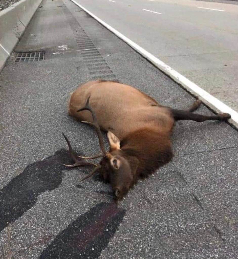
That’s right, elk! Ever since elk were re-introduced to the Smokies and not-so-far-away areas of Kentucky, folks have wondered if the animals would expand their range and re-populate the Rocky Fork area. The elk seen dead beside I-26 at Sam’s Gap on October 12 is a sign that the elk are coming towards Unicoi County—and they may have already been here for some time.
Bull elk killed on I-26 East just below Sam’s Gap on October 12. Image by Stephanie Thomas Wood.
“Animals that pop up in Western North Carolina or East Tennessee are not always from the Smokies, but I think our herd is the source for most,” said Kim DeLozier of the Rocky Mountain Elk Foundation. “It’s also possible that they moved from Kentucky or maybe someone even released captive elk.”
It’s exciting to think we may soon be able to see elk when we hike in Rocky Fork. But there are concerns that we must be prepared to address if we are going to welcome these animals back to these mountains they once roamed. Much larger than deer, elk are grazers and and thus can cause problems for farmers, so we will need to work together and communicate with elk researchers in order to deal with new issues and limit damage.
Due to their size, elk also create a dangerous situation when they get out on our roads. There is a documented rise in motor vehicle collisions with wildlife throughout East Tennessee and Western North Carolina. Due to increasing populations—both animal and human—as well as growing tourism in the area, it is expected that this situation will only get worse.
“We counted up to 60 elk this fall on tribal lands, and elk like to move great distances,” said Caleb R. Hickman, supervisory fish and wildlife biologist with the Eastern Band of Cherokee Indians (EBCI). “Right now, over 40 elk are known to walk across Highway 19, and another 12 across the Blue Ridge Parkway, where the mountains create tight, windy roads with blind curves. These smaller highways are particularly dangerous to elk and people.”
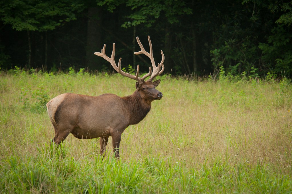
Bull elk in Cataloochee Valley, Great Smoky Mountains National Park. Image by Joye Ardyn Durham.
Liz Hillard, a wildlife scientist with the nonprofit Wildlands Network, and Steve Goodman, a wildlife researcher with National Parks Conservation Association, are researching how roadways in East Tennessee and Western North Carolina influence the connectivity of bear, deer and elk habitat. They are conducting road mortality surveys and procuring mortality data from state agencies (TDOT, NCDOT and NCWRC) along I-40 in the Pigeon River Gorge to determine wildlife mortality hotspots. They are also working with partners to put GPS collars on elk to assess roadway movement patterns and elk road-crossing behavior.
“The frequency of elk–vehicle collisions is likely to increase through time as road networks continue to expand, the elk population continues to grow, and traffic volume increases,” Hillard says. “This research will provide information to guide mitigation strategies to increase human safety, reduce elk–vehicle collisions, and increase the connectivity of public lands as elk disperse.”
We would love to hear of elk sightings, living or dead, and will pass the information on to researchers. Email Frances Figart with any images or information.
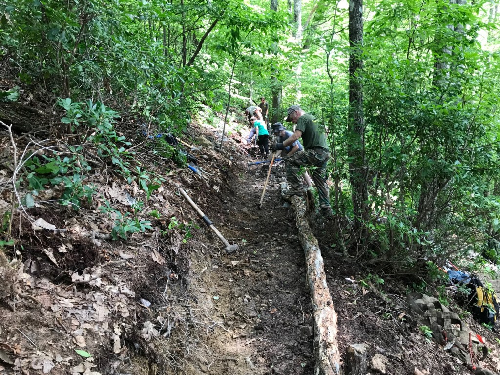
The Rocky Fork Trail Crew, aka “trail gorillas,” have been working for about ten months now building a new Whitehouse Cliffs Trail to replace the old “trail,” which is plagued with numerous problems. The regular crew is made up of volunteers and Friends group members along with the park ranger, and we have also have received help from Carolina Mountain Club and Tennessee Eastman Hiking & Canoeing Club.
So far, more than one mile of new trail is complete, climbing over 800 feet in elevation from the starting point. The Whitehouse Cliffs, which the trail passes near, are visible from I-26 near the rocky summit of the mountain. The trail building has been challenging due to the steep slope of the mountain requiring a lot of digging to create a shelf wide enough for the trail, as well as the numerous areas with no soil to dig in, only rocks, which must be moved and fitted together into a trail.
Here are a few photos by Van Hovey from this week’s adventures.
Hikers in Lamar Alexander Rocky Fork State Park. Image by Joye Ardyn Durham
On June 2, an op ed column by David A. Ramsey appeared in the Johnson City Press criticizing those opposing the overdevelopment of Rocky Fork State Park. Johnny Cosgrove of Tennessee Citizens for Wilderness Planning and Christian Hunt of Defenders of Wildlife—two of the many folks hoping to change the plans for the park—responded with letters to the editor that you can read here.
Numerous statements in the article by Ramsey suggest that he is not fully informed about the state’s plans, which may well be the case since he has spent the last few years focused on developing the Northeast Tennessee Regional Economic Partnership. For example, Ramsey says there would not be RVs, but the plans state clearly that the road is designed to accommodate them.
He also says Unicoi County citizens “made a major compromise and commitment, exchanging their support for the development of a multi-million dollar residential resort for that of preserving a true Tennessee mountain treasure and creation of a new state park to help their economy” and that “if a state park could be established on at least part of the tract, it would ultimately offset the economic loss of both current and future property tax revenue, which the county very much needed.”
First of all, that large residential resort development was very unlikely to have ever come about; a consultant concluded that the site was unfeasible for development and the ostensible would-be buyers had to defend themselves in court over numerous crooked deals. Second, Tennessee’s Conservation Compensation Fund pays the property taxes for the state park land. Third, although it is less than what private owners would pay in property taxes, the federal Impact Aid Program annually pays counties with large federal land ownership: $61,000 for Unicoi County in 2019—and this from an owner who does not even expect county services in return.
Indeed a residential resort development in Rocky Fork would have brought in additional taxes. But, after providing all the services expected in return, the county would likely have had to raise taxes. Now, as a result of preserving this special place, tourism will bring many visitors and the county will benefit economically—if it has the infrastructure in place to take advantage of the increase in visitors. Large development within the park would only destroy the natural beauty of the larger tract (which is what draws tourists) making it impossible to ever recoup the $23 million spent on the road.
Perhaps the best argument against Ramsey’s article is provided on page 81 of his own book, Rocky Fork: Hidden Jewel of the Blue Ridge Wild: “The Cherokee National Forest, that covered nearly half of the county, comprised a largely untapped economic asset of major proportions, and, in our assessment, adding the spectacular Rocky Fork Watershed to that asset would increase its long term value to the community by far more than what might be derived from property taxes alone.” His is a beautiful publication in which he tells the story of Rocky Fork’s “salvation” from development. But what his audience needs to realize is, the story doesn’t end with Dave’s book: the Rocky Fork tract is still under threat—this time from the state itself.
We are still expecting meetings and/or a chance for public input on those plans when the new leaders at TDEC get up to speed on the issue. We will keep you up to date until then.
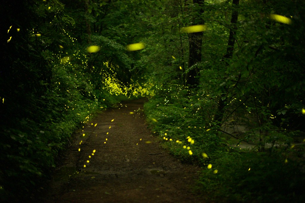
Synchronous Fireflies in Rocky Fork State Park by Radim Schreiber of FireflyExperience.org.
While there are still plenty of the more common firefly species to be seen over fields and forests in our area, the “season” for the incredible Blue Ghost and Synchronous firefly has just about ended.
We were fortunate to have Radim Schreiber, an accomplished expert photographer of fireflies, stop in after his work in the Smokies to have a look at our spectacular Rocky Fork fireflies and capture this image.
Radim, who lives in Iowa and is originally from the Czech Republic, has been photographing insects since 1999. Visit FireflyExperience.org to see many more incredible photos and videos of fireflies and the beautiful book and prints he has produced. You can also follow his work on Facebook.
Good news from Rocky Fork: the wildflowers have been great, the fireflies are coming out, and the unofficial word from state officials is the Flint Mountain road project is “on hold.”
In spite of the fact that TDEC is officially still waiting for the permits required to begin building a road through Rocky Fork, and that road opponents were led to believe there would be additional discussion and public input, on May 6 we went into the park to discover a group of engineers preparing to “start clearing the road right-of-way.”
The firm had been awarded a $300,000 contract to perform geotechnical surveying in areas where road structures (like 750 feet of retaining walls up to 27 feet high holding back fill dirt up to 30 feet deep) would be located to determine if the designs are compatible with existing soil and geology. This work would require clearing trees and some dozer work to get a large drilling rig along the path of the road to drill core samples—in effect going ahead and starting to tear up the area we want to protect.
This was disconcerting to say the least, especially given the fact that a few weeks earlier, on April 16, Defenders of Wildlife, Tennessee Citizens for Wilderness Planning and several other area conservation organizations met with new TDEC Commissioner David Salyers to request that he reconsider plans for Rocky Fork State Park. Salyers said many letters had been received calling attention to the lack of support for the development plans and that he intends to look into the situation and seek additional public input before moving ahead with the project.
Salyers has appointed Jim Bryson as Deputy Commissioner of Parks and Conservation, a position that has been temporarily filled by Anne Marshall since the removal of Brock Hill earlier this year. So, with new leadership in place and the message of the need to review the plans for Rocky Fork delivered, it seems we will get another chance to provide public input.
Also, the park recently grew by 88 acres with the acquisition of the “Sparks Tract,” which joins the parklands just above the “blue hole” along the entrance road and continues down to state highway 352. This property could provide an alternative site for a campground with much easier access than the proposed site up on Flint Mountain.
So, for all of us who were disappointed with the Rocky Fork plans presented last November—and who are hoping the state will not repeat mistakes made in the past and not create a park similar to others but one that is singular in the area and showcases Rocky Fork’s unique characteristics as the wildest Tennessee state park—we now have the opportunity we have hoped for.
But we cannot just rest on our laurels. It’s now time to prepare for your chance to provide input, write down your ideas for alternatives to a road, look for examples from other parks around the world that illustrate the effectiveness of your ideas, talk to others and get them involved too, so that when the time comes we have our ideas ready to present.
When I was a kid growing up in the woods of East Texas, I joined Defenders of Wildlife and pored through the stories each month in their magazine—and that contributed to my growing love of nature. When they asked for volunteers to help capture the last Red Wolves, my dad and I went down and helped track the wolves and even got to see two of them loping along in the salt marsh.
The red wolf is still hanging on, but just barely, and at a recent event I met some folks with Defenders of Wildlife who are still at it, protecting our treasured wildlife. I was pleasantly surprised when one day I had a message waiting for me that Defenders had gotten word of the issue of development in Rocky Fork and the harm it would do to the wildlife and wanted to help me in my quest to protect the place and its natural wonders.
The mission statement of Tennessee state parks reads in part “to protect and preserve the unique natural, cultural and historic resources of Tennessee.” The State Parks Act of 1937, which created the parks, reads in part “that every park under the provisions of this act shall be preserved in its natural condition, so far as to be consistent with its human use and safety, and all improvements shall be of such character as not to harm its inherent recreational values.”
The current development plans for Rocky Fork State Park are not consistent with these provisions and should be revised, with an abundance of public input, until they are. The following fact sheet was recently prepared by three conservation organizations to help raise awareness of the threat Rocky Fork faces. Please feel free to show it to friends or contacts who want or need to know more about what is going on. Feel free to email me if you cannot readily access the document or want a PDF or another format.
Other voices besides our own have begun to be raised and heard on the issue. We appreciate anything and everything you do to help Rocky Fork. Sharing information, even with a few people, goes a long way toward the overall goal of making everyone who loves this place aware of the situation. Thank you!
Last November, after three years of relative silence, the Tennessee Department of Environment and Conservation finally presented to the public their plans for the first stage of “improvements” in what was to be the “minimally developed” Rocky Fork State Park. Part of the plan is a 24-foot-wide, two-lane, paved road that begins with a bridge over Rocky Fork Creek and extends ¾ mile to a campground and scenic overlook on Flint Mountain.
The photo below shows the approximate route of the road, now estimated by TDOT to be a $23 million dollar project, designed so as to be able to accommodate RVs and 2,000 to 4,000 vehicles per day. Due to the rugged and steep terrain, extensive use of retaining walls, massive road cuts, and metal reinforcement bolted into rock on slopes above would be required, leaving an ugly scar on Rocky Fork. Also, take note of the fact that a future stage of this development would be to widen the existing Rocky Fork Road to similar standards, changing the “prettiest mile of road in Tennessee” forever.
If this isn’t what you want to see in Rocky Fork I suggest a letter to the new Commissioner of TDEC, David Slayers (David.Salyers@tn.gov) and/or the interim Deputy Commissioner of State Parks, Anne Marshall (Anne.Marshall@tn.gov), asking that these plans, developed by the previous administration, be re-visited and public input sought to arrive at a better plan that the public supports, before permanently damaging the natural beauty we worked so hard to protect.